I was at a garden center on Wednesday, and I asked one of the women who was working there how she was doing. She just replied, “Cold,” and walked away, covering up a bunch of plants. The owner of the nursery, who knows me, saw me and said, sarcastically and with a chuckle, “Are you looking for snow-hardy annuals?”
Indeed, it has been chilly. Around 4 p.m., Wednesday, Logan Airport was sitting at 48 degrees — that’s 20 degrees below the average high temperature for this week in May. It won’t snow with our upcoming nor’easter, but it does kind of feel like it.
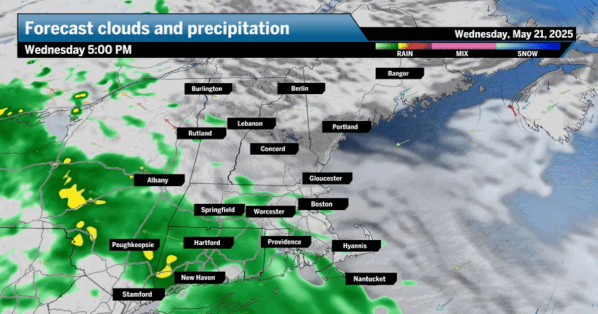
On Thursday, as a low-pressure area over the Great Lakes redevelops along the coastline, an area of rain will continue to press north into New England. Any showers from this nor’easter Thursday morning will turn to a steady windswept rain through the afternoon. And it will be a cold rain because temperatures will only reach 50, maybe 52 in spots.
As the storm moves up the coastline, the wind will increase, gusting to 50 miles an hour and making it feel quite chilly. A wind advisory is in effect from Maine to the Cape from 2 p.m. into the evening. Also, a coastal flood advisory has been posted for Thursday evening for Massachusetts, Rhode Island, and Connecticut. These advisories are issued when there will be some minor splash-over along shoreline roads. We see this a lot during coastal storms that aren’t significant.
The heaviest rain is going to take place during the evening commute through the early-morning hours of Friday. By the time all is said and done, I think there’s going to be some areas that see up to 3 inches of rain, even if most of us receive between 1 and 2 inches.
The downpours could cause flooding of streams and rivers and some ponding on streets.
If this were mid-winter and we had extra cold air available, I’d be forecasting 10 to 20 inches of snow across the region, but of course, it’s not. Where there will be snow is up in the mountains. Indeed, the freezing level will lower itself to just under 3,000 feet, meaning that the higher elevations are definitely going to see some mixed precipitation.
The morning commute on Thursday will likely have wet roads and a few showers, but the heaviest rain will be hours away. The wind will be increasing through the morning and become a bit gusty at times, but nothing extreme. By the tail end of this window, the rain will become heavier.
It will also be an unusually cold May day. Temperatures will start out in the mid-40s.
This is the core of the storm. Rain will be steady and at times heavy. The intensity will vary during the afternoon, and you could even hear the rumble of thunder. The wind will be gusty, especially along the coastline, where gusts between 35 and 45 miles per hour could occur. This isn’t strong enough to cause anything other than very isolated power issues.
You should plan on a very wet evening commute.
Temperatures will range between 45 and the low 50s during the entire afternoon — 20 degrees below average.
As low pressure continues to move northeast and passes Boston, the rain will shut off. There may be a few lingering showers, but after midnight, little additional accumulation of rainfall will occur.
Friday brings a few morning showers, but nothing major. Clouds may break in the afternoon for a little bit of sunshine, but if we do see it peek through, it’s going to be very brief. Temperatures will be a bit milder, getting into the 50s as opposed to the 40s the day before. Wind will not be a factor. If you are driving into Maine, the rain will last all day up there on Friday.
Greater Boston: Showers turn to a steady rain Thursday with temperatures only in the 40s. Winds will be a bit gusty during the afternoon. Look for more rain overnight before tapering off to showers Friday. Highs Friday in the 50s.
Central/Western Mass.: Steady rain continues during the day with temperatures 45 to 50. It will be a bit breezy at times. The rain comes to an end after midnight. Evening lows in the 40s. Highs in the 50s Friday with cloudy skies and a brief shower.
Southeastern Mass.: A windswept rain arrives Thursday with temperatures only in the 40s to near 50. Look for rain in the evening, heavy at times. Temperatures hold in the 40s. Some areas could see nearly 3 inches by the time rain ends Friday morning. Look for cloudy skies on Friday.
Cape Cod and Islands: Look for some minor beach erosion at the time of high tide Thursday with rain heavy at times, accumulating 2 to 3 inches. Winds will be gusty, and it will be chilly with highs in the 50s. It remains mostly cloudy Friday.
Rhode Island: Rain heavy at times for Thursday. Temperatures will be near 50 in the afternoon with a gusty wind and 1 to 2 inches of rain. Look for clouds with highs near 50 on Friday.
New Hampshire: Rain arrives during the morning on Thursday with highs only in the mid-40s and it is breezy. Rain continues Thursday night and into Friday morning. Highs Friday in the lower 50s. Some snow in the very highest elevations.
Vermont: Rain and very cool for Thursday with highs only 40 to 45. Look for showers during Friday with highs only in the 40s. There may be some snow mixed in during the morning. More showers are around Friday.
Maine: There’s a wind advisory posted along the main coastline with rain arriving in the afternoon on Thursday. Highs will be 45 to 50. Rain continues Thursday night with temperatures near 40. Rain continues much of Friday.
The weather improves further on Saturday with temperatures near 60, and we approach the upper 60s for Sunday and lower 70s on Monday with the most sunshine for the second half of the weekend.
Sign up here for our daily Globe Weather Forecast that will arrive straight into your inbox bright and early each weekday morning.