OMAHA, Neb. (WOWT) – Tornado sirens went off in Omaha at about 7 p.m. after a tornado touched down north of the city near 72nd Street.
Sirens were also going off in Bennington and Elkhorn, and people at Eppley Airfield were taking shelter.
The National Weather Service put the tornado’s location about seven miles east of Bennington, near Florence.
The Omaha-metro had been bracing for a strong thunderstorm since Thursday afternoon after high winds blew through Dodge County and large hail fell in Fremont.
Strong winds kicked up a dust cloud big enough to force drivers to pull off Highway 30 near Rogers and North Bend as concerns grew about a potential tornado in that area. A tornado warning was issued for Dodge County at about 6 p.m.
Those in the path of this storm are advised to take shelter. Winds could get up to 80 miles per hour.
Hail reports have been coming in at about 2-3 inches, but baseball-sized hail was reported in Fremont. Radar was showing that the hail threat seemed to be weakening — more like 1-2 inch hail — as the storm moved into Douglas County near Bennington. But First Alert 6 was getting reports of very large hail — the size of a person’s hand.
PREVIOUS COVERAGE
A Tornado Watch has been issued for the metro and surrounding counties until midnight tonight. The ingredients are present to potentially form a tornado or two.
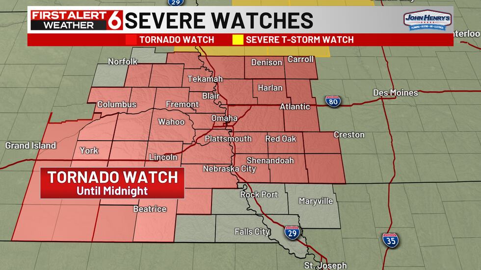
Tornado Watch has been issued for the metro through midnight tonight.(wowt)
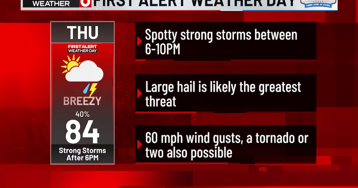
Today is a First Alert 6 Weather Day due to the threat of isolated severe storms later on tonight between 6 PM – 10 PM.

First Alert 6 Weather Day(WOWT)
A few strong storms are going to form to our west near or after 5-6pm and move eastward toward the metro. The models show just a couple of intense storms developing with the best odds near and north of I-80. By 10 PM, there’s a possibility of one last strong storm moving through the area then it’ll quite down afterwards.

An isolated strong storm or two looks to form around 6 PM.(wowt)

More strong storms may form late around 10 PM.(wowt)
The few that develop run the risk of producing large hail, perhaps as large as baseballs. Damaging gusts are possible too reaching up to 60 mph and we’ll have to wait for tornado to try to develop from the strongest storm but those threats are less than the hail risk.

Severe Weather Risk(WOWT)
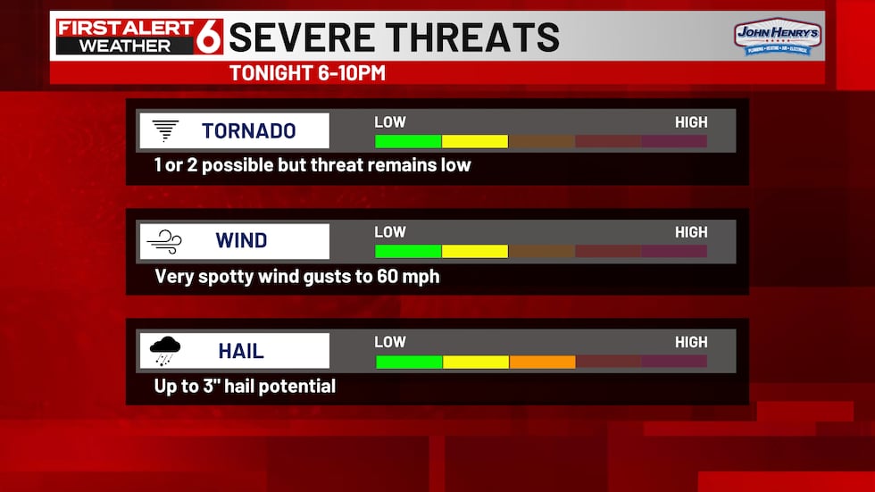
Large hail is the biggest threat as hail could be as big as a baseball.(wowt)
After this, the clouds will lock in tonight and Friday making it a struggle to warm much of Friday. Highs in the lower 50s are now likely with clouds and a northwest wind all day long.
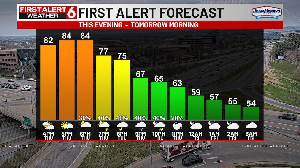
6-10 PM is the best timeframe for storms then stays cloudy afterwards.(wowt)

Friday WInds(First Alert 6)
Rain continues to look likely on and off on Easter Sunday too. That will keep it cooler than most of you would like as well.

More showers and storms are possible on Easter and next week.(wowt)
Copyright 2025 WOWT. All rights reserved.