Better keep that umbrella handy as the Kansas City area faces daily chances for rain through the start of next week, according to the National Weather Service.
Rain continues to linger in the metro area, mainly along Interstate 70, which could lead to a few sprinkles for Wednesday morning’s commute and errands, the weather service said in its forecast discussion.
A brief break is expected before another weather disturbance moves through late in the morning into the afternoon, bringing the chance for rain for areas north of Interstate 70. The weather service said severe weather is not expected with that round of storms.
“Extensive cloud cover through the day associated with showers and storms could keep temperatures a few degrees cooler than (Tuesday),” the weather service said.
Temperatures reached 79 degrees on Tuesday and are expected to be in the mid-70s on Wednesday. Typically, Kansas City’s temperatures are 68 degrees this time of year.
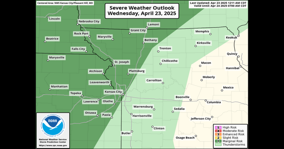
Strong to severe storms in Kansas City’s forecast
The weather service said another weather disturbance is expected to move across the area Wednesday evening, bringing yet another round of showers and storms.
The storms are expected to develop in eastern Kansas and move east into the metro area, mainly impacting areas east of Interstate 35, the weather service said.
A few of the storms could be strong to severe, with the main threats being large hail and strong to damaging winds, the weather service said.
The National Weather Service’s Storm Prediction Center has placed parts of eastern Kansas and the northwest corner of Missouri, including the Kansas City metro, under a marginal risk of severe weather.
The severe storms are expected to diminish as they move further east into Missouri.
Rain from the storms is expected to linger into Thursday morning. Temperatures on Thursday will climb into the mid-70s.
Heavy rains possible overnight
More showers and thunderstorms are expected Thursday night into Friday morning, but the weather service said severe weather is not likely.
However, the National Weather Service’s Weather Prediction Center has placed the western half of Missouri at a slight risk for excessive rainfall, mainly if the storms track over the same locations.
Areas likely to see the highest rainfall totals remain uncertain, but generally, areas west of U.S. 65 in central Missouri are at risk of more than 1 inch of rain.
The rain is expected to continue into Friday morning and end in the afternoon. Temperatures are expected to be in the low 70s.
Weekend storms possible in the metro
Most of the area will be dry on Saturday, mostly cloudy with temperatures returning to normal.
Another weather disturbance is expected to approach from the south, which could bring showers to central Missouri late Saturday.
More storms are possible late Sunday into Monday.. There is also a slight risk of severe weather on Monday, but it’s uncertain how intense the storms will be.
There is a slight chance of severe weather on Monday, but it’s uncertain how intense the storms will be, according to the National Weather Service. The National Weather Service’s Storm Prediction Center
This story was originally published April 23, 2025 at 7:28 AM.