You’ve been reading mock drafts for weeks and weeks. You’ve read countless ones on this website alone. How about one more? Here’s my best bet as to what happens during the first round of the 2025 NFL Draft. And by best bet, I’m confident this will be wildly off base.
1. Tennessee Titans, Cam Ward, Miami QB
The worst-kept secret in the NFL.
2. Cleveland Browns, Travis Hunter, Colorado CB/WR
Travis Hunter is a unicorn. Teams love his attitude as well. Hunter won the pre-draft process and jumped Carter because of it.
3. New York Giants, Abdul Carter, Penn St Edge
The Giants can’t pass up one of the top two players in the draft, especially because there’s a drop after him.
4. New England Patriots, Will Campbell, LSU OL
The Patriots really hurt themselves by winning in week 18. This is arguably the worst place to draft. Campbell is not good enough to be picked fourth, but the Patriots need trench help and miss out on Hunter and Carter because of that week 18 win.
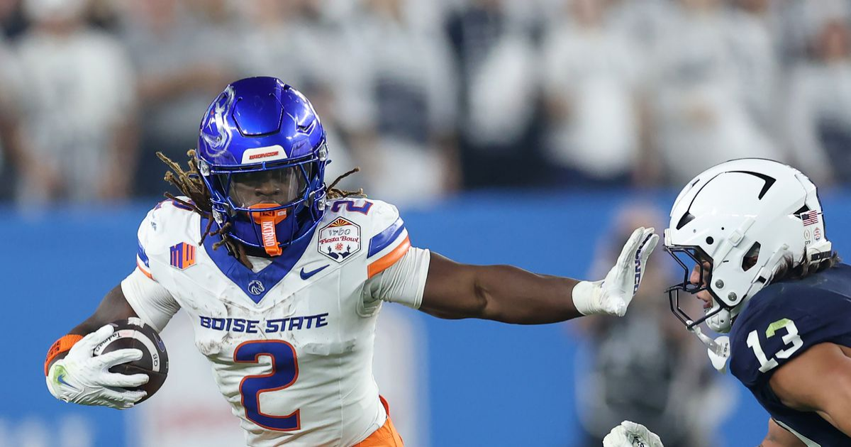
5. TRADE: Chicago Bears, Ashton Jeanty, Boise St RB
Ben Johnson is smitten. He has a QB. He has a TE. He has a couple of WRs. He needs his RB. The Bears trade 10 and 41 for 5 and 107.
6. LV Raiders, Armand Membou, Mizzou OT
The Raiders need to build up the trenches on both sides of the ball. They could consider Mason Graham here with the issues with Christian Wilkins, but they decide to help keep defenders off Geno Smith.
7. NY Jets, Tyler Warren, Penn State TE
The Jets could take Kelvin Banks here, but they want to add offensive weapons, and Justin Fields is not shy to throw to tight ends.
8. Carolina Panthers, Jalon Walker, Georgia LB
Another place for Graham, but the Panthers have been doing plenty of work on Walker, and they decide that he is, in fact, their man.
9. New Orleans Saints, Mykel Williams, Georgia Edge
Many people think the Saints will take a QB here, but the Saints don’t do anything that people expect. They could use trench help, and Williams is just that.
10. TRADE Jacksonville Jaguars, Tet McMillan, Arizona WR
McMillan is exactly the guy that Liam Coen wants for Trevor Lawrence. Not only that, they pick up an additional second-round pick and get their top guy.
11. San Francisco 49ers, Mason Graham, Michigan DT
The Mason Graham drop ends. The 49ers were considering Walter Nolen here, but with Graham on the board, they make the move.
12. Dallas Cowboys, Matthew Golden, Texas WR
The Cowboys helped for McMillan, but they take their WR2 once he’s off the board.
13. Miami Dolphins, Kelvin Banks, Texas OL
Tua doesn’t need to take more hits. Banks has been a popular name to go in the top 10, but he slides a little out of it, and the Fins grab him.
14. Indianapolis Colts, Colston Loveland, Michigan TE
The Colts try to move up for Loveland once Warren is off the board, but nobody is willing to budge, but they still land their man.
15. Atlanta Falcons, James Pearce, Tennessee Edge
Falcons have been searching for a quality edge for a while. Pearce is their next attempt.
16. Arizona Cardinals, Jihaad Campbell, Alabama LB
Campbell is a unique linebacker talent, and the Cardinals are pleased he falls to them.
17. Cincinnati Bengals, Mike Green, Marshall Edge
On the field, Green was arguably EDGE2 in this draft; off the field, not so much. Bengals are always willing to bet on talent, and they place one here.
18. Seattle Seahawks, Will Johnson, Michigan CB
Will Johnson was considered a top 5 player in this draft in August. A couple of issues have dropped him down the list, but Mike McDonald is thrilled to bolster his defense here.
19. Tampa Bay Buccaneers, Malaki Starks, Georgia S
The Bucs could go a few different ways here, but they simply see a talented football player here who has a high floor and take the safe pick.
20. Denver Broncos, TreVeyon Henderson, Ohio State RB
The world has thought Omarion Hampton would be the pick here, but the Broncos surprise everyone, and Henderson is their RB2 on their board.
21. Pittsburgh Steelers, Omarion Hampton, UNC RB
The Steelers run the card in after they assumed Hampton wouldn’t be one of their options at 21.
22. LA Chargers, Mason Taylor, LSU TE
This might be the biggest surprise in round one. However, Jim Harbaugh thinks Taylor could be a cornerstone of his offense.
23. Green Bay Packers, Jahdae Barron, Texas CB
Barron has been mocked as high as six and as low as round two. The Packers could go a few different directions here.
24. Minnesota Vikings, Derrick Harmon, Oregon DL
Harmon could turn into a real wrecking ball in Brian Flores’ defense.
25. Houston Texans, Josh Conerly, Oregon OT
After a failed attempt to move up for Kelvin Banks, the Texans are quite pleased with their consolation prize. Conerly has been steadily climbing draft boards all offseason.
26. TRADE New York Giants, Tyler Shough, Louisville QB
The crowd will react if the Giants move up like this for Shough, especially with Jaxson Dart and Shedeur Sanders still on the board but the Giants like Shough and Joe Schoen and Brian Daboll, who are on the hot seat, need a QB who can look good in 2025 and Shough gives them the best chance for that.
27. Baltimore Ravens, Tyler Booker, Alabama G
The Ravens just love to find really good football players, and Booker is that guy. He’s scheme-dependent, but put him in the right scheme, and he’s going to be a 10-year wrecking ball for a football team.
28. Detroit Lions, Grey Zabel, North Dakota St C
Even without Ben Johnson, the Lions continue with their strategy of building a strong offensive line. Zabel has position flexibility, and that’s something that Zabel could utilize in becoming the Lions’ top backup at multiple offensive line spots as a rookie.
29. Washington Commanders, Shemar Stewart, Texas A&M Edge
Stewart was rumored to go in the top ten a few weeks ago, but production defeated projection for many teams. Dan Quinn stops the slide and believes he can develop Stewart into a cornerstone piece of his defense.
30. Buffalo Bills, Kenneth Grant, Michigan DT
Some scouts around the league thought Grant was more of a problem for opposing offenses than Graham. Grant is a big body that will get snaps immediately in the Bills’ rotation.
31. Kansas City Chiefs, Josh Simmons, Ohio State OT
Simmons has some fabulous tape. Simmons also has some health and motivation questions. The Chiefs believe their culture will win out, and the health is worth a roll of the dice.
32. Philadelphia Eagles, Walter Nolen, Ole Miss DT
Howie Roseman closes out round one drafting a player that some projected to go towards the top ten. He continues his streak of finding great value in the draft.