ATLANTA – While the metro Atlanta area has received a teasing of spring weather the last few days, all that is about to change heading into the weekend. The FOX 5 Storm Team is tracking a significant severe weather threat from Saturday night into Sunday morning.
Strong to severe thunderstorms are expected to impact most of North Georgia with the strong possibility of damaging winds, tornadoes, hail in some parts, and flash flooding.
Weekend Severe Weather Threat
What they’re saying:
Saturday morning will bring scattered showers and storms, especially north of Atlanta. However, the severe weather risk remains low during the morning hours.
One change in the forecast is that Saturday afternoon now looks mostly dry, with cloudy skies and temperatures in the upper 70s. But don’t let the quiet conditions fool you—the main threat arrives after 8 p.m. Saturday night into early Sunday morning.

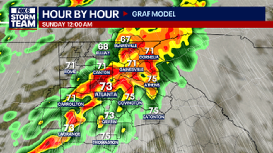
Severe Storms Expected Late Saturday – Early Sunday
What Is Expected:
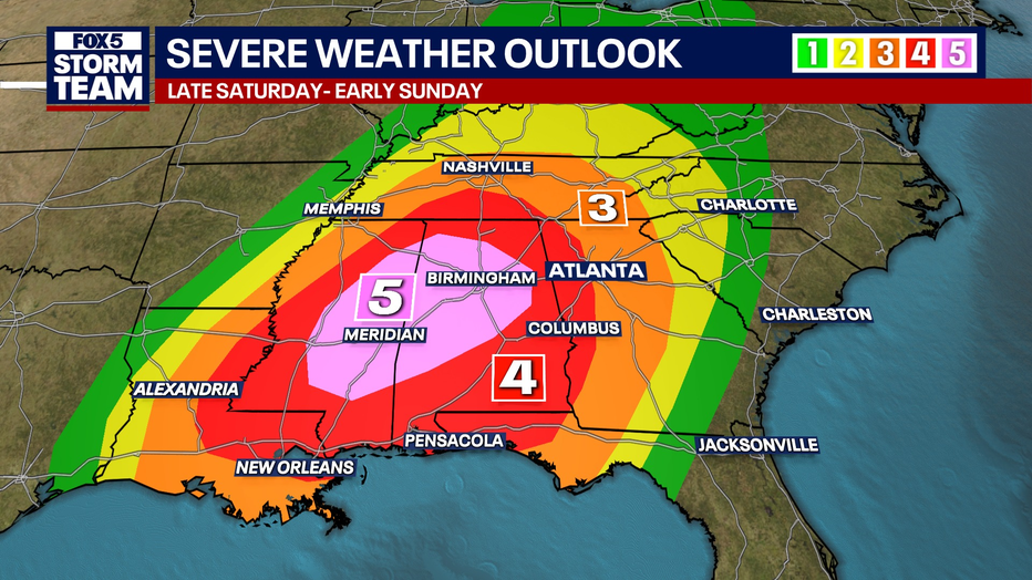
A powerful storm system will move into Georgia Saturday night bringing the potential for all severe weather hazards. At this time, western Georgia is at a level 4 risk for severe storms, including Cobb, Douglas, Bartow, and Coweta counties. The rest of North Georgia is at a level 3 for severe storms, which is still a notable risk. The following are possible:
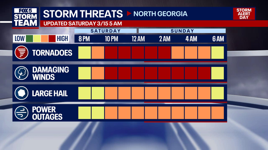
- Damaging winds (60-70 mph) that could bring down trees and cause power outages
- Large hail (1 inch in diameter or greater)
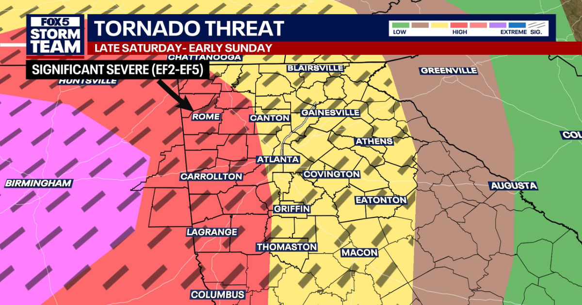
- Strong tornadoes (EF-2 or greater possible), mainly west of Atlanta
- Localized flash flooding in some areas
RELATED: How to prepare for possible tornado and severe weather
TORNADO RISK: It is very easy to look at the risk in Alabama and think, “Oh, it’s going to be over there.” That’s not the case. The risk is extreme back into central Alabama and Mississippi. We have a HIGH risk of tornadoes west of I-75 tonight and an ELEVATED risk of tornadoes east of I-75. The black hash marks from the Storm Prediction Center indicate that EF2–EF5 tornadoes will be possible.
WIND RISK: Aside from tornadoes, winds of 60–70 mph will be possible and could easily topple trees across metro Atlanta and north Georgia. Take Severe Thunderstorm Warnings seriously tonight—you could see the same level of damage as a tornado, just from damaging winds.
HAIL RISK: Hail is likely the least of our concerns tonight. It will be possible but only up to about an inch in diameter.
Please know where your tornado safe place is. For many people, that’s a basement. If you don’t have a basement, go to the lowest level of a sturdy structure, in the most interior room, away from windows, and put as many walls between you and the outside as possible.
If you live in a manufactured or mobile home, please leave tonight—these structures are not safe in a tornado threat. Likewise, if you live in a house with a foundation and know someone in a mobile or manufactured home, please invite them to stay with you through the overnight hours.
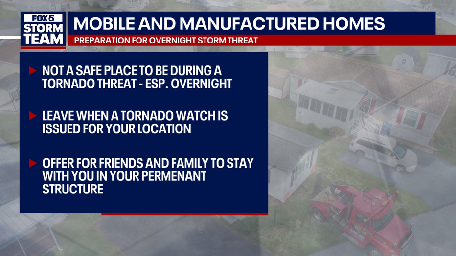
Gather essential items now to put in your tornado-safe place or to take with you if you are leaving a mobile home. These can include important documents, prescriptions, and food/water. Have items like pillows, blankets, helmets, hard-soled/closed-toe shoes, and flashlights on hand.
Officials bracing for storm damage
Dig deeper:
In Brookhaven, officials are shutting down the Peachtree Creek Greenway on Friday afternoon ahead of the weekend’s storms.
The trail is set to stay open until storms move out of the area on Sunday morning. Officials say high winds and flash flooding could make the trail dangerous.
Georgia Power says it is tracking the storm and crews are prepared to respond to any issues quickly.
DeKalb County weather emergency shelters
DeKalb County will open four severe weather centers for residents seeking shelter starting at 8 p.m. Saturday.
The list of shelters is below:
- Frontline Response International, 2585 Gresham Road, Atlanta, 30316.
- North DeKalb Senior/Community Center, 3393 Malone Drive, Chamblee, 30341
- Mason Mill Recreation Center, 1340 McConnell Dr., Decatur, 30033
- Exchange Park Intergeneration Center, 2771 Columbia Dr., Decatur, 30034
Transportation pickups will also be available in parts of the county. You can find the full list on DeKalb County’s website.
Overnight Danger: Stay Weather Aware
Why you should care:
Saturday has been declared a Storm Alert Day by FOX 5 Atlanta. The severe storms will push into the Atlanta metro area by midnight, making it critical to have a way to receive weather alerts that will wake you up if needed. This will be a fast-moving system, and while flash flooding is less of a concern, damaging winds and tornadoes are the main threats.
Weather officials say Georgia residents who live in mobile or other manufactured homes should find another place to shelter due to the severe weather.
By Sunday morning, the storms will move southeast, and most of the rain will clear out by sunrise.
Stay with FOX 5 Atlanta for the latest updates as this system develops. Be sure to download our STORM TEAM weather app and enable emergency alerts to stay informed overnight Saturday into Sunday.
You can also watch FOX 5 Atlanta for free on the FOX LOCAL app. Just click here to find out how to get it on your connected TV or cellphone.
Additionally, NOAA weather radios are also reliable sources of information in emergency situations.
Looking Ahead
Coming Up:
After the stormy weekend, Sunday afternoon is expected to stay dry, with a much calmer and pleasant start to next week. Temperatures will remain mild, with sunshine returning Monday.
Severe WeatherAtlantaGeorgiaNews