The National Weather Service is warning Alabamians that they could be in for three rounds of severe storms starting on Thursday.
Forecasters think the risk for severe weather could climb each day, culminating on Saturday, when widespread severe storms and tornadoes (some of them strong ones) will be possible statewide.
In addition, 2 to 3 inches of rain will be possible in parts of the state, which could lead to some localized flooding.
The weather service said that timing and areas with the highest threats will be narrowed down as each round approaches.
There will be one more day of pleasant weather first, today, with warm temperatures and no rain expected statewide.
Things change starting on Thursday.
NOAA’s Storm Prediction Center has expanded a Level 1 out of 5 risk for severe weather for a large part of Alabama for Thursday.
Here’s the severe weather outlook for Thursday:

A large part of Alabama will have a Level 1 out of 5 risk for severe weather on Thursday.SPC
A Level 1 risk means that isolated severe storms will be possible. The strongest storms could contain damaging winds, hail up to golf ball size and heavy rain. The threat for tornadoes will be lower with Thursday’s round of storms.
Storms on Thursday will be possible from the later morning hours through the early evening, according to weather service forecasts.
Forecasters expect storms to develop in Mississippi and move eastward into Alabama during the day on Thursday.
Here’s the timing for possible storms on Thursday:
NORTH ALABAMA

Here’s when storms could affect north Alabama on Thursday.NWS
CENTRAL ALABAMA

Here’s the outlook for central Alabama for storms on Thursday.NWS
SOUTHEAST ALABAMA

Storms could affect southeast Alabama on Thursday afternoon.NWS
Then on Friday the risk level ramps up to a Level 3 for northwest Alabama and a Level 2 for part of north and central Alabama.
Areas in east and southwest Alabama will have a Level 1 risk, and severe storms aren’t expected in southeast Alabama.
Here’s the outlook for Friday:

A Level 3 out of 5 risk for severe weather has been added for northwest Alabama on Friday.SPC
A Level 3 risk means that numerous severe storms will be possible.
Friday’s storms could produce tornadoes, according to the weather service, as well as damaging winds and heavy rain.
Friday’s storms won’t make it to Alabama until Friday night — starting as late as 9 p.m., according to weather service forecasts. They could last until the early morning hours of Saturday.
Alabamians are urged to make sure they have a reliable way of getting severe weather warnings that could wake them up if needed.
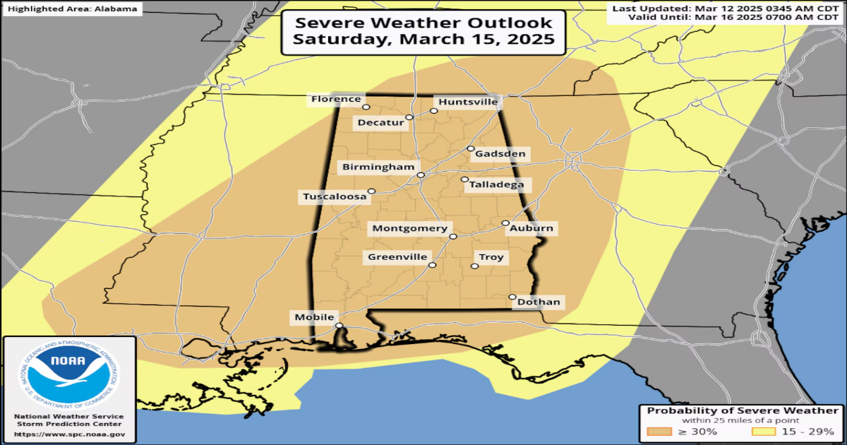
The final round — and potentially most significant — round of storms will take shape on Saturday.
The Storm Prediction Center has placed nearly all of Alabama in its long-range equivalent of a Level 3 out of 5 risk for severe weather for Saturday. (The outlook for Saturday is at the top of this post.)
Saturday could bring widespread severe storms, and some of them could produce strong tornadoes (EF-2 or stronger).
There could also be wind gusts as high as 70 mph, hail up to the size of tennis balls, and heavy rain that could lead to localized flooding, according to forecasters.
Storms will be possible throughout the day on Saturday and could last into the early morning hours of Sunday.
Forecasters think activity could peak starting in the afternoon on Saturday with individual super cell storms possible ahead of another line of severe storms that will sweep through the state from west to east.
The weather service said more timing details about Saturday’s storms will come into focus over the next few days.
Storms are expected to clear out of the state during the day on Sunday, and no severe weather is in the forecast for Alabama through next week.