DANGEROUS SEVERE THUNDERSTORM/TORNADO OUTBREAK AHEAD: Most of Alabama will be dry, mild, and breezy today, but a dangerous outbreak of severe thunderstorms and tornadoes is expected across a large area beginning late tonight. Alabamians will need to pay very close attention to the weather tonight through tomorrow night as a dynamic storm system will bring two rounds of severe thunderstorms.
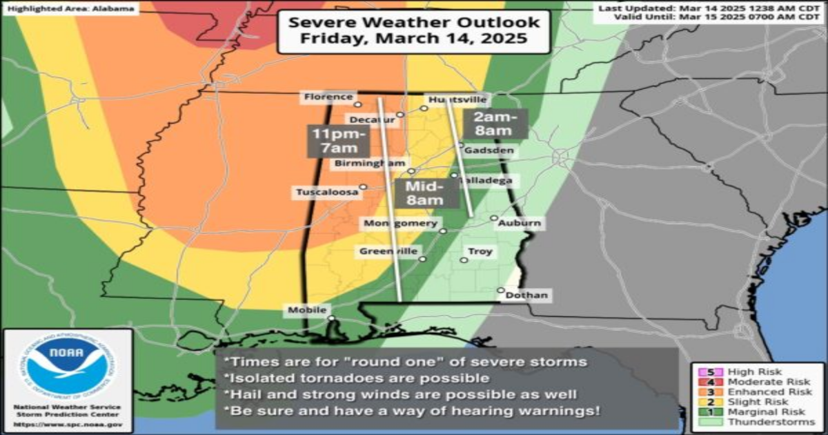
ROUND ONE
*The broad window for the first round of severe thunderstorms will come from around 11:00 tonight through 8:00 a.m. tomorrow.
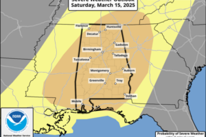
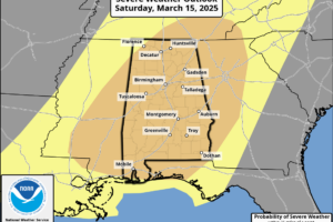
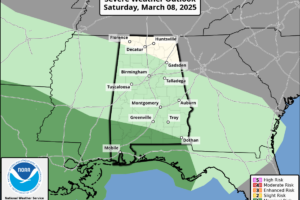
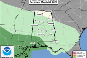
*SPC has defined an “enhanced risk” (level 3/5) for much of West Alabama for this event, with a “slight risk” (level 2/5) as far east and south as Scottsboro, Prattville, and Jackson.
*Highest risk of severe storms with “round one” will be over the western half of the state, mainly along and west of I-65. The severe threat is much lower over the eastern counties, where the air will be more stable.
*Where storms develop, they will be capable of producing hail and damaging winds. A few tornadoes are possible as well, mainly over West Alabama.

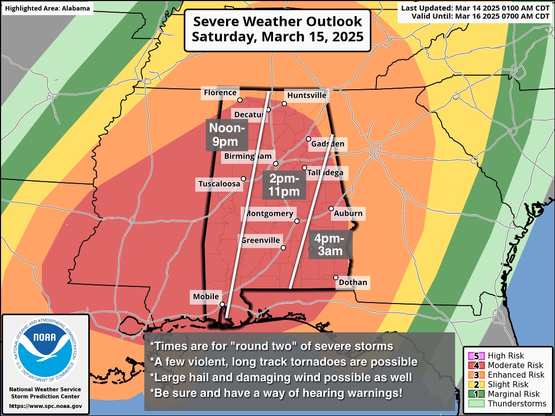
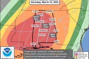
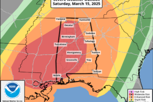
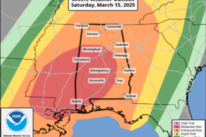
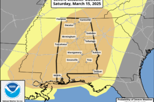
ROUND TWO
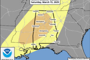
*This is the “main event”; the window is from 12 noon tomorrow through 3:00 a.m. Sunday.
*A “moderate risk” (level 4/5) covers most all of Alabama in the “Day 2” outlook issued by SPC.
*Storms will be capable of producing large hail, damaging winds, and tornadoes. A few violent, long track tornadoes are possible.
KEY MESSAGES
*We don’t use strong wording often, but in this case it is needed. The threat is real, and the event poses a dangerous situation for all of Alabama and most of the southern U.S. The goal is no loss of life, and no serious injuries; we all have a big role to play.
*It is critical that you hear warnings. An outdoor siren is never, ever a primary way of hearing warnings. The “siren mentality” has killed more people than anything else during tornado events in Alabama. The baseline for every home and business is a NOAA Weather Radio; unfortunately many retailers have sold out of them due to the high demand this week. On your phone, be sure emergency alerts are enabled in notification settings… this is the tone you hear for tornado warnings and amber alerts. Have the free ABC 33/40 weather app installed. Turn the sleep/do not disturb modes OFF for the weekend so you will receive notifications at night.
*In your safe place, have helmets for everyone, including adults. Most serious injuries in tornadoes involve blunt force trauma above the shoulders. Wearing hard shoes is also a good idea. Have a portable air horn for everyone; they can alert first responders to your location if you are injured.
*If you live in a mobile home, know the location of the nearest shelter, or business open 24/7 that can serve as a shelter. Have transportation arranged so you can get there quickly. You cannot stay in a mobile home if you are in a tornado warning polygon.
*A car is a death trap during a tornado. If you are driving and get a tornado warning notification, pull off as quickly as possible and go into a gas station, fast food restaurant, or any other business that can serve as a shelter.
*You can be a hero. If you are reading this, you pay attention to weather. Let friends and family members today know this is a dangerous threat. During the event, if you have a friend or loved one in a tornado warning polygon, call or text them to let them know of the immediate danger. You can play a huge role in saving lives.
*Subscribe to the James Spann and ABC 33/40 YouTube channels so you can watch our live coverage. During the event itself all of my attention is focused on the live coverage. We are thankful for the out of state YouTubers who do long form severe weather coverage, but to be truly successful in reaching people and communicating warnings in high end severe weather events like this, you have to understand the people, culture, geography, and microclimate of the region impacted.
*We don’t share any of this to scare people. But strong wording is necessary on occasion, and this is one of those times. Get the warnings, have a good plan, and we get through this together.
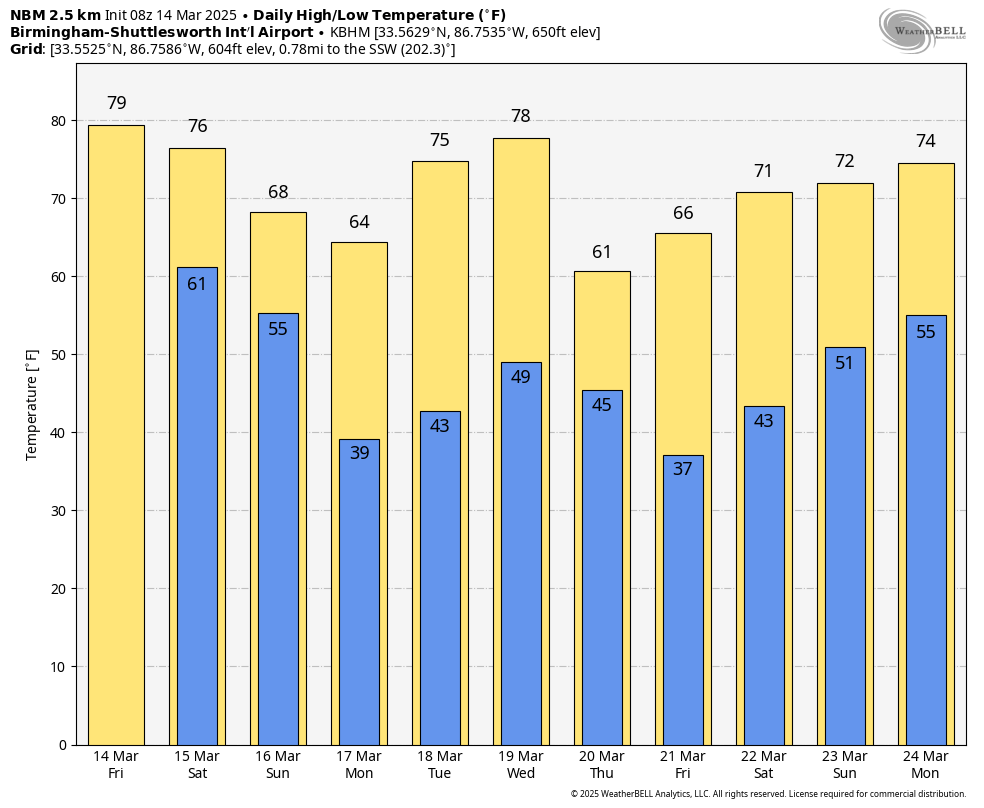
The sky will clear Sunday, but a few isolated showers are possible during the afternoon hours as the upper trough passes through.
NEXT WEEK: Most of the week will be dry, but a cold front will bring a band of showers and storms into the state late Wednesday and Wednesday night. For now it does’t look like a major severe weather threat… See the video briefing for maps, graphics, and more details.
ON THIS DATE IN 1993: Birmingham’s low was 2 degrees, a record low for the month of March. It came when one foot of snow was on the ground from the Blizzard of 93.
Look for the next video briefing here by 3:00 this afternoon… enjoy the day!
Category: Alabama’s Weather, ALL POSTS, Weather Xtreme Videos
Page 2
 DANGEROUS SEVERE THUNDERSTORM/TORNADO OUTBREAK AHEAD: A dangerous outbreak of severe thunderstorms and tornadoes is expected across a large area beginning late tonight. A dynamic storm system will bring two rounds of severe thunderstorms.
 SEVERE THUNDERSTORM/TORNADO OUTBREAK AHEAD: Most of Alabama will be dry, mild, and breezy day, but a dangerous outbreak of severe thunderstorms and tornadoes is expected across a large area beginning late tonight.
 RADAR CHECK: We have a few thunderstorms on opposite ends of the state this afternoon… one cluster is near Muscle Shoals, the other is over the southeast tip of the state near Dothan. Some small hail is possible with these storms… the rest of the state is dry with a mix of sun and clouds along with temperatures in the 70s.
 SHOWERS LATER TODAY: Alabama is rain-free just before daybreak, but a few showers and storms will pass through the state later today ahead of a fast moving disturbance. SPC maintains a low end “marginal risk” of severe thunderstorms for much of the state.
 SUNNY MARCH DAY: With sunshine in full supply, temperatures are in the 70s across Alabama this afternoon. Clouds will increase late tonight; most communities will see a low in the 50s.
ONE MORE DRY DAY: With a partly to mostly sunny sky today, we project a high in the 75-80 degree range this afternoon. Clouds will increase tonight, and a few showers and thunderstorms are likely tomorrow.
 BLUE SKY: We have a cloudless sky across Alabama this afternoon with temperatures in the 70s. Tonight will be clear and cool with a low in the 46-54 degree range.
 NICE WARM-UP TODAY: Colder spots are in the mid 30s across North Alabama early this morning, but we expect a high in the 70s statewide today with a good supply of sunshine. No change tomorrow; dry and mild with highs in the 70s.
 IMPROVING WEATHER: The sky has becoming sunny across the northern 2/3 of Alabama this afternoon as dry air returns; clouds over the southern counties will move out this evening. Tonight will be mostly clear with a low in the 40s. We might see a few spots over North Alabama in the upper 30s.
 RADAR CHECK: We have large areas of rain across parts of Alabama this morning; the rain should be out of the state completely by early afternoon, followed by gradual clearing. Temperatures will rise into the low to mid 60s this afternoon.
 PLEASANT MARCH AFTERNOON: Temperatures are in the 65-72 degree range across Alabama this afternoon with a partly to mostly sunny sky. Clouds will increase tonight, and a few spotty showers are possible as moisture levels rise.
 STILL DRY TODAY: After a chilly start early this morning with temperatures in the 30s in many areas, we are forecasting a high in the 67-73 degree range this afternoon with a partly sunny sky. Clouds will increase tonight, and a few spotty showers are possible as moisture levels begin to rise.
 BLUE SKY: With a cloudless sky temperatures are in the 50s over North Alabama, with low to mid 60s for the southern counties. Tonight will be clear with a low in the 33-43 degree range.
 CHILLY START: Some of the colder spots across North Alabama have dropped into the low 30s early this morning.. we expect a high in the 50s across North Alabama today with a sunny sky; South Alabama will rise into the low 60s. Tomorrow will be warmer with 60s statewide as the sky will remain mostly sunny.