Buckle up, Ohio. This weekend’s weather is about to take us for a ride.
The summer-like temperatures on Friday will give way to high winds and possible severe thunderstorms on Saturday, followed by more rain on Sunday. And keep the sinus medication handy, because this weekend’s weather will bring a cooldown into early next week.
Here’s a look at the forecast.
Severe weather outbreak possible in Ohio on Saturday, high wind advisory in effect for Cincinnati, Columbus
The National Weather Service has issued a high wind advisory from 2 a.m. to 8 p.m. Saturday for portions of west central, southwest and central Ohio, including Columbus and Cincinnati. South winds of 20 to 30 mph are in the forecast, with gusts of 50 mph possible.
“Gusty winds will blow around unsecured objects. Tree limbs could be blown down, and a few power outages may result,” the NWS said in a statement.
Risk of severe thunderstorms, tornadoes today in Mississippi Valley
According to the NWS’ storm prediction center, there is a moderate risk of severe thunderstorms today in the mid-Mississippi Valley and lower Ohio Valley, including portions of Illinois, Iowa, Missouri, Kentucky and Tennessee. The storms could spawn several strong tornadoes, as well as generate wind gusts of 60 to 100 mph and baseball-sized hail.
However, the state of Ohio is on the fringe of that weather today, with a marginal risk of that severe weather.
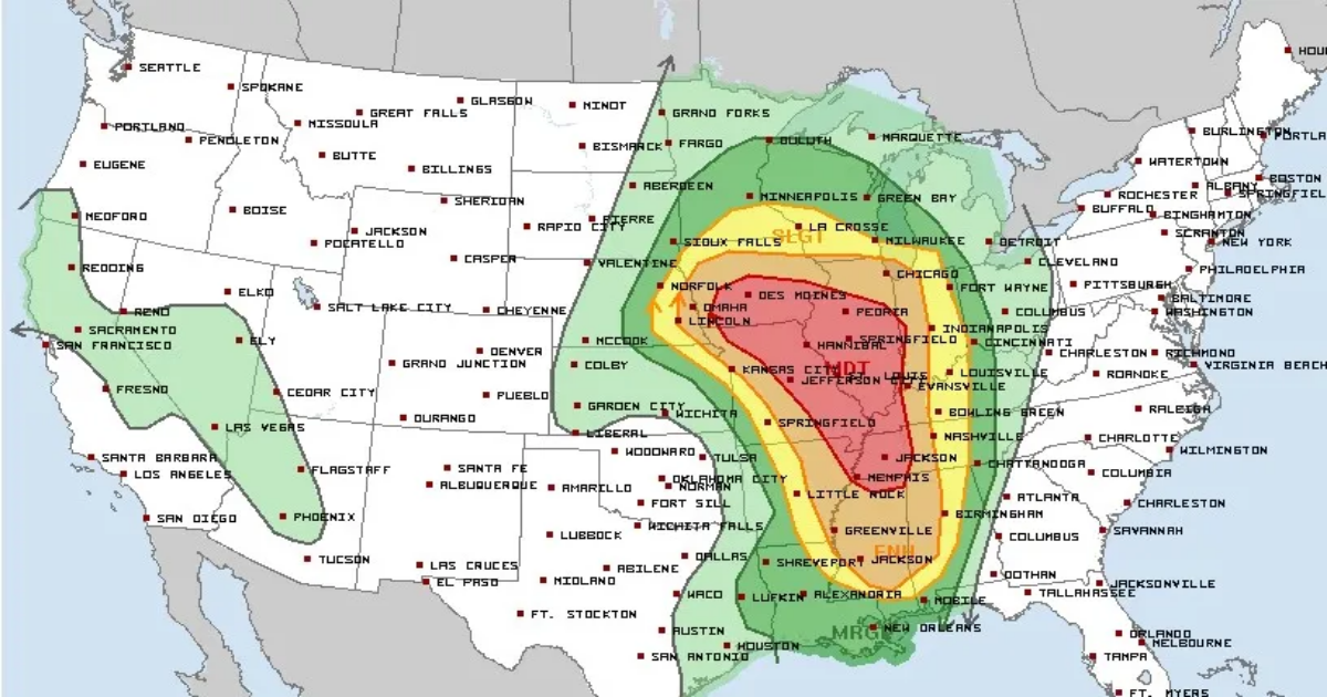
Severe weather forecast for Saturday, March 15
On Saturday, the NWS forecast shows the severe weather heading south into portions of Louisiana, Mississippi, Alabama and Florida, where there is a moderate risk of severe thunderstorms and tornado outbreaks.
“Numerous significant tornadoes, and some long-track tornadoes are expected on Saturday afternoon and evening, centered on eastern Louisiana, Mississippi, and Alabama. Widespread damaging wind swaths and scattered large hail are likely,” the forecast states.
Most of Ohio is upgraded to a slight risk of severe weather.
Weather forecast for Akron, Columbus and Cincinnati
Here’s a look at the NWS extended weather forecast for Akron, Columbus and Cincinnati:
- Akron: A high temperature near 75 degrees today is forecast, with partly cloudy skies tonight. On Saturday, showers and possible thunderstorms are in the forecast, with a high of 72. A south wind of 17 to 23 mph could gust to 41 at times. More rain is the forecast on Sunday, with a high of 64 and south winds of 14 to 17 mph gusting to 31 possibly. The cooldown continues Monday with a high of 52, but will warm up on Tuesday and Wednesday with highs of 67 and 71, respectively.
- Columbus: Today’s high will reach 78. Saturday will bring showers and possible thunderstorms, with a high of 74. A south wind of 21 to 23 mph could gust as high as 39. Sunday will bring more showers and a high of 62, with south winds of 10 to 15 mph. Monday will be cooler, with a high of 55. But the temps will climb on Tuesday, with a high of 69, and Wednesday, with a high near 71.
- Cincinnati: Today’s high will hit 80. Showers and thunderstorms are likely on Saturday, with a high near 74. South winds of 18 to 20 mph could gust as high as 37. On Sunday, showers and a possible thunderstorm are in the forecast, with a high of 59, which is also the forecast high temperature on Monday. Tuesday and Wednesday are expected to be mostly sunny, with a high of 71 each day.