Video: Winter weather advisory for snow and rain through Monday evening
Kevin Skarupa is tracking impact weather that should bring light snow across the state. Snow could change to rain in some areas Monday afternoon.

Latest system moving in today starting as some light snow as it moves in, we’ll be looking for milder air to try to take over going into the afternoon, switching that light snow over to light rain in southern parts of the state. While farther north, *** lot of this falls in the form of light snow before wrapping up late in the day and in this evening, temperatures starting the day in the 20s and climbing into the 30s through the afternoon. We do have *** winter weather advisory posted for central parts of the state. This goes through. 8 o’clock this evening. I expect the back edge of this precipitation to move through somewhere between 6 and 8 p.m. for southern areas of the state by this afternoon. It will be in the form of light rain while farther north through central and northern areas likely most of this, if not all of it, falling in the form of light snow. Here’s the possibility as far as accumulation and again *** lot of this for southern areas of the state will likely be just on grassy areas and things improving greatly by the time. We get to the evening commute farther north again, temperatures in the twenties this morning. Some of this will be sticking to area roadways and then getting better gradually through the afternoon. This is *** very classic late March situation where travel impacts will become greater later this morning and early this afternoon before lessening late in the day with lighter precipitation and eventually into this evening. Today is the one day with highs mostly in the 30s. We get back. The 40s with partial sunshine starting tomorrow and the 40s going forward heading toward the end of the week. So after the colder air moved in yesterday with that brisk northwesterly wind, we now have cold enough air in place that the initial portion of the storm system will be in the form of light snow everywhere. From there we change over to light rain in southern areas. There’s your highs today which will mostly be above 32. This is gonna help area roadways going into the afternoon. Notice we are running *** solid 10 degrees below the average for this time of year. Light winds initially, but those will pick up out of the Southeast later in the day and into this evening. This is *** look at noon. We here again we’ll be seeing that switch over from that light snow to light rain in southern parts of the state. Central and northern areas likely staying as light snow. There is your back edge making its way across the state late in the day and early this evening. Nothing more than *** passing shower with partial clearing overnight. Untreated surfaces could be *** bit slippery overnight or first thing tomorrow morning with lows in the 20s to lower 30s. Partial sunshine, couple of snow showers up north tomorrow, and quite *** few more clouds around on Wednesday. There will be *** system passing to our south, and it could mean *** rain or *** snow shower on Wednesday depending on the time of day in which that arrives. And then we’re back to partial sunshine for both Thursday and Friday. There’s *** 7 day forecast which has 40s going forward all the way through the end of the week.
Video: Winter weather advisory for snow and rain through Monday evening
Kevin Skarupa is tracking impact weather that should bring light snow across the state. Snow could change to rain in some areas Monday afternoon.
Updated: 5:00 AM EDT Mar 24, 2025
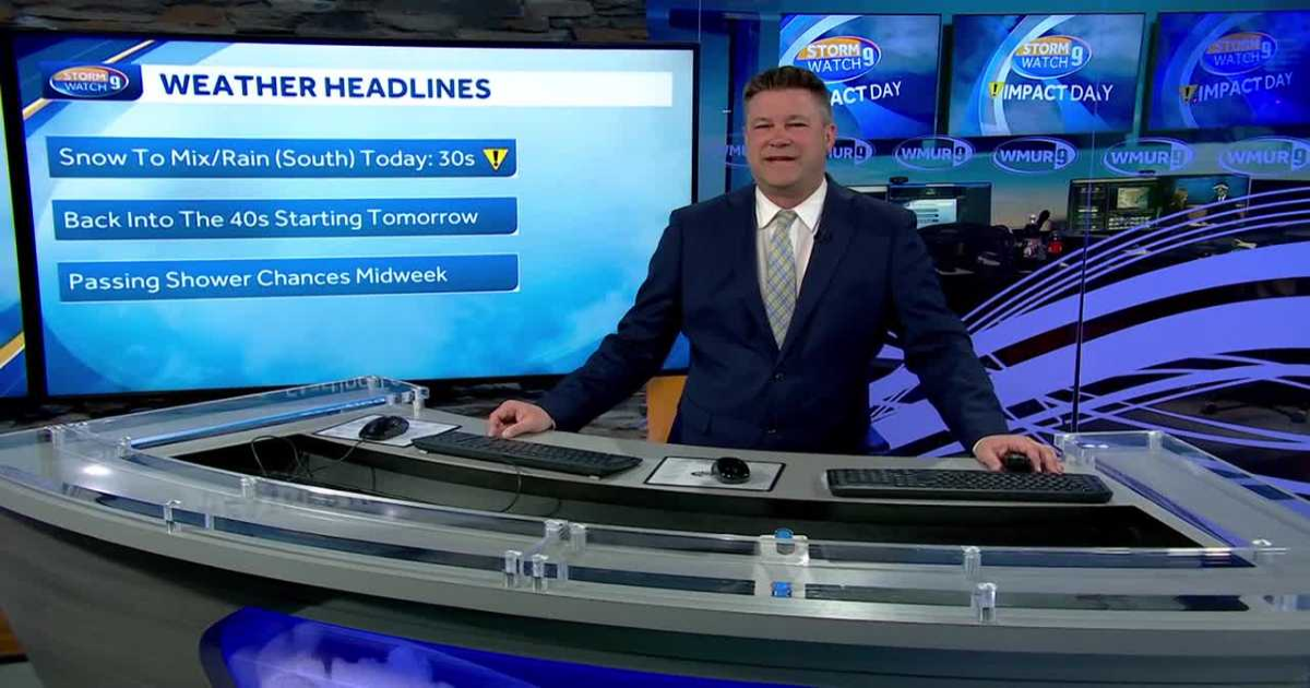
The latest system with some light snow and light rain moves through today ahead of a mostly quiet rest of the week along with seasonable temps.Light snow developing this morning will change to rain from south to north this afternoon. Scattered coatings to 1 inch are possible from Rochester to the Merrimack Valley south of Concord and in the Monadnock Region, with the best chance of 1 to 3 inches of snow from just north of Concord to the Lakes Region and north and west. 3-5 inches is likely to fall from Plymouth north and east into the Mount Washington Valley. Roads could be slick mid-morning into the early pm, especially in areas north and west of Concord.Any showers (rain or snow) end this evening, but as temps fall into the 20s to lower 30s overnight any untreated surfaces could be slippery.Milder 40s on Tuesday with partial sunshine and a northwesterly breeze.Temperatures will be staying seasonable for late March through midweek along with some sun and some clouds each day.
The latest system with some light snow and light rain moves through today ahead of a mostly quiet rest of the week along with seasonable temps.
Light snow developing this morning will change to rain from south to north this afternoon. Scattered coatings to 1 inch are possible from Rochester to the Merrimack Valley south of Concord and in the Monadnock Region, with the best chance of 1 to 3 inches of snow from just north of Concord to the Lakes Region and north and west. 3-5 inches is likely to fall from Plymouth north and east into the Mount Washington Valley. Roads could be slick mid-morning into the early pm, especially in areas north and west of Concord.
Any showers (rain or snow) end this evening, but as temps fall into the 20s to lower 30s overnight any untreated surfaces could be slippery.
Milder 40s on Tuesday with partial sunshine and a northwesterly breeze.
Temperatures will be staying seasonable for late March through midweek along with some sun and some clouds each day.