ATLANTA — Storms are moving into west Georgia on Thursday afternoon with tornado and flood watches active throughout metro Atlanta and north Georgia.
Already, multiple Severe Thunderstorm Warnings have been issued. One for the City of Atlanta, including Hartsfield-Jackson Atlanta International Airport, was issued just before 1 p.m. through 1:45 p.m.
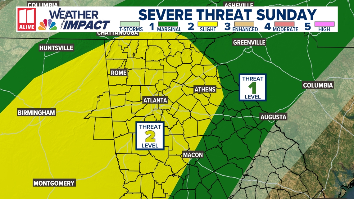
Much of our area is highlighted by the Storm Prediction Center level 2 “Slight” risk. While storms will be weaker by the time they reach north Georgia, isolated strong storms could still produce heavy rain, frequent lightning, and gusty winds.
The Braves game was postponed ahead of the storms. A ground stop is in effect at the airport through 2 p.m.
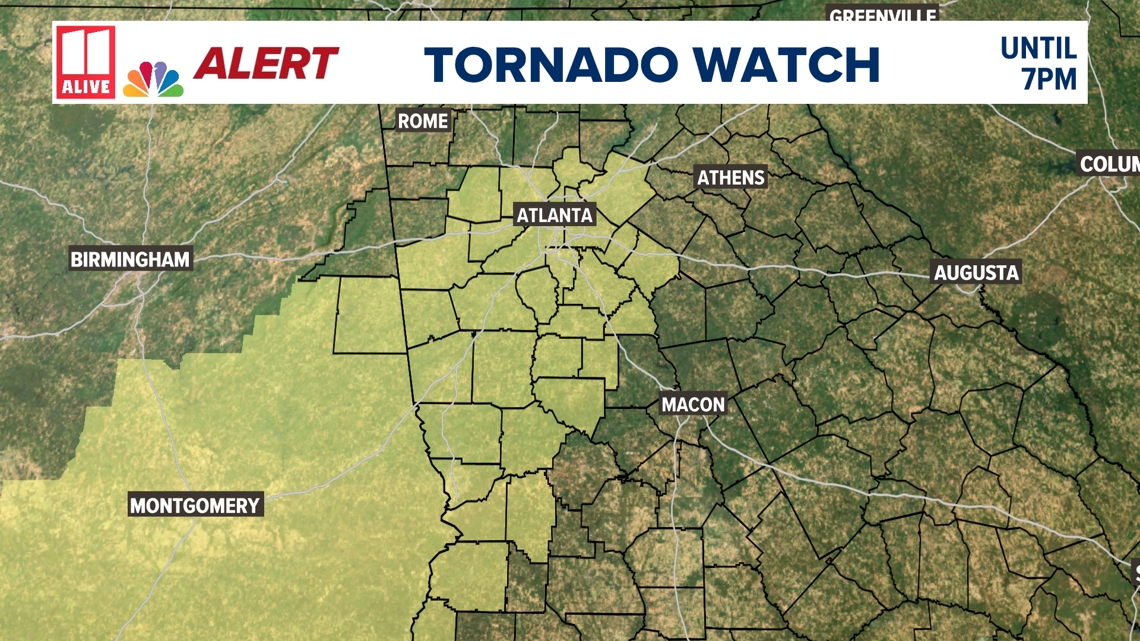
A Tornado Watch will be in effect for the core metro Atlanta counties of Fulton, Gwinnett, DeKalb, Cobb and Clayton until 7 p.m. Other counties included in the watch are: Fayette, Pike, Rockdale, Butts, Lamar, Coweta, Meriwether, Troup, Upson, Henry, Newton, Spalding. This is in effect until 7 p.m.
A Flood Watch is in effect through 8 p.m. for the Georgia counties of Fulton, DeKalb, Cobb, Gwinnett, Clayton, Dade, Walker, Catoosa, Whitfield, Murray, Fannin, Gilmer, Union, Towns, Chattooga, Gordon, Pickens, Dawson, Lumpkin, White, Floyd, Bartow, Cherokee, Forsyth, Hall, Banks, Jackson, Madison, Polk, Paulding, Barrow, Clarke, Oconee, Oglethorpe, Haralson, Carroll, Douglas, Rockdale, Walton, Newton, Morgan, Greene, Heard, Coweta, Fayette, Spalding, Henry, Butts, Jasper, Putnam, Troup, Meriwether, Pike, Upson Lamar, Monroe, Harris, Talbot, Muscogee and Chattahoochee.


- 2:06 p.m. | Severe threat mostly past us for now, though a secondary line is moving through Alabama currently and heavy rain is ongoing.
- 1:49 p.m. | Another special weather statement for 50mph winds in DeKalb, Gwinnett, Henry, Newton, Rockdale, Walton counties.
- 1:42 p.m. | A special weather statement — not at the level of a warning — was put out for strong storms, 50mph winds in Butts, Henry, Jasper, Newton, Rockdale and Spalding counties until 2:30 p.m.
- 1:30 p.m. | Nasty stuff coming with this storm!
The rain and wind have arrived pic.twitter.com/v4Ws8WHKfP
— Cody Alcorn (@CodyAlcorn) April 6, 2025
- 1:13 p.m. | The Severe Thunderstorm Warning that was issued for Carroll, Cobb, Douglas, Paulding and a bit of south Fulton was expired.
- 1:03 p.m. | Ground stop at Hartsfield-Jackson until 2 p.m. The FAA gives that a 30-60% chance of being extended.
- 1 p.m. | That last severe warning includes the City of Atlanta and Hartsfield-Jackson Atlanta International Airport:
Severe Thunderstorm Warning including Atlanta GA, Hartsfield-Jackson Atlanta Airport GA and North Atlanta GA until 1:45 PM EDT pic.twitter.com/8fmrratgEj
— NWS Atlanta (@NWSAtlanta) April 6, 2025
- 12:58 p.m. | A Severe Thunderstorm Warning has been issued for Fayette, Fulton, Henry, Rockdale, DeKalb, Clayton and Spalding counties until 1:45 p.m.
- 12:48 p.m. | The first Severe Thunderstorm Warning we had was canceled for Carroll and Heard counties but continues for Coweta, Fayette, Meriwether and Troup until 1:15 p.m.
- 12:45 p.m. | We’ve also gotten our first report of a tree down on a house in Coweta County.
- 12:44 p.m. | A look at the two active warnings:
Severe Thunderstorm Warning including Smyrna GA, Mableton GA and Douglasville GA until 1:15 PM EDT pic.twitter.com/8Lw2HTfz3N
— NWS Atlanta (@NWSAtlanta) April 6, 2025
Severe Thunderstorm Warning continues for Peachtree City GA, Newnan GA and Tyrone GA until 1:15 PM EDT pic.twitter.com/9IAFKRSoNv
— NWS Atlanta (@NWSAtlanta) April 6, 2025
- 12:41 p.m. | A Severe Thunderstorm Warning has been issued for Fulton, Paulding, Douglas, Carroll and Cobb counties until 1:15 p.m.
- 12:38 p.m. | National Weather Service now indicating tornado possible with the Severe Thunderstorm Warning below.
- 12:30 p.m. | A Severe Thunderstorm Warning has been issued for Carroll, Coweta, Fayette, Heard, Meriwether and Troup counties until 1:15 p.m.
- 12:15 p.m. | Flood Watch that is in place for numerous metro Atlanta and north Georgia counties is extended to 8 p.m.
- 12:10 p.m. | Special weather statement including 40mph winds for Carroll, Cobb, Douglas, Paulding, south Fulton counties until 12:45 p.m. A reminder that a special statement is not at the level of a warning.
Special Weather Statement [wind: 40 MPH, hail: 0.00 IN] for Carroll, Cobb, Douglas, Paulding, South Fulton [GA] till 12:45 PM EDT https://t.co/uK8BaSF9QJ pic.twitter.com/0JzsE0asqd
— IEMBot FFC (@iembot_ffc) April 6, 2025
- 12:07 p.m. | The Braves game has been postponed because of the incoming weather. It was rescheduled for Saturday, Aug. 9 as part of a double header.
Today’s game against the Miami Marlins has been postponed due to inclement weather. This game has been rescheduled for Saturday, August 9th at 1:15 PM ET as part of a split doubleheader. Gates will open at 11:30 AM ET for the 1:15 PM ET game.
Your ticket from the April 6th…
— Atlanta Braves (@Braves) April 6, 2025
- 11:58 a.m. | 11Alive Meteorologist Nicole Hartford will be live in the video player above this story momentarily with another live report.
- 11:55 a.m. | No warnings being issued yet, but a line of thunderstorms is going to impact Carroll, Heard, Troup and Coweta counties through 12:30 p.m.
Strong thunderstorms will impact portions of southern Carroll, Heard, northwestern Troup and western Coweta Counties through 1230 PM EDT [wind: 40 MPH, hail: 0.00 IN] https://t.co/SBvID3rBx0 pic.twitter.com/ghCXtTLqRF
— IEMBot FFC (@iembot_ffc) April 6, 2025
- 11:10 a.m. | If you’re in the inner metro and wondering where this weather is supposed to be, 11Alive Meteorologist Nicole Hartford is explaining in a live report currently playing in the video player at the top of this story that we’re about an hour or two away from the rain really setting in.
- 11:00 a.m. | Here’s that expanded tornado watch through 6 p.m. It includes Fulton County as well as Cobb, Clayton, DeKalb, Gwinnett, Butts, Coweta, Fayette, Henry, Lamar, Meriwether, Newton, Pike, Rockdale, Spalding, Troup and Upson, as well as a few additional ones around Columbus that are outside our viewing area. Randolph County, AL, which we are responsible for, is also in the watch.
- 10:35 a.m. | Here’s some info on a new watch that could soon be issued:
NWS and Storm Prediction Center coordinating on a possible new watch that could include more of west Georgia and the metro area. We will let you know if they issue a new one. pic.twitter.com/o06HSKubJh
— ChrisHolcomb11Alive (@ChrisHolcomb) April 6, 2025
- 10:05 a.m. | 11Alive Chief Meteorologist Chris Holcomb is currently live in the video player above this story!
- 9:45 a.m. | We’ll begin live streaming coverage ahead of the storms in about 15 minutes. In the meantime we also have an update on the tornado watch being canceled now in Chattooga, Gordon and Floyd counties.
- 8:05 a.m. | Little update on the tornado watch — it’s been canceled for Catoosa, Murray, Walker and Whitfield counties in northwest Georgia.
- 7:15 a.m. | Good morning! Some storms have already reached far northwest Georgia — a special weather statement, which does not rise to the level of a warning, was already issued a few times this morning for lines that passed through north Georgia, and there were Severe Thunderstorm Warnings for Fannin, Gilmer, Dade, Walker and Murray counties in the overnight hours. Closer to the City of Atlanta, we’re expecting storms closer to lunchtime.
DOWNLOAD THE 11ALIVE APP:
- Download the app on your Apple or Android device.
- Set up weather notifications by clicking the Gear icon in the upper right corner of the app. Select Notification -> Notification Settings -> Severe Weather Alerts -> Toggle the Severe Weather Alerts button to the right to turn alerts on.
- Send photos and videos through the app by selecting the Near Me feature on the bottom right taskbar of the app and entering your information.
TEXT YOUR WEATHER PHOTOS TO US: 404-885-7600
JOIN THE 11ALIVE WEATHER IMPACT TEAM’S FACEBOOK GROUP: Nearly 10,000 metro Atlanta and north Georgia weather enthusiasts share their weather photos every day. Click here to join the group!
