A dynamic storm system will bring a slew of threats, from heavy rain and the potential for flooding to heavy snow, severe thunderstorms, damaging winds and even wildfire risk from coast to coast in the days ahead.
The storm will first approach the West Coast on Wednesday, with valley rain and mountain snow developing from Seattle to San Diego.
Then early Thursday, the storm, carrying an atmospheric river, will bring a band of heavy rain to Los Angeles, where a flood watch has been issued and debris flows from wildfire burn scars are possible.
Significant snowfall is expected across the Intermountain West through Friday before the strengthening storm emerges in the Plains and Midwest. There it may generate strong tornadoes, damaging winds and a risk of fires from Friday through Saturday.
And finally on Sunday, a band of heavy rain and wind may sweep across the Eastern Seaboard as the system gradually moves offshore.
Here’s a regional breakdown of what to expect in the days ahead.
Valley rain and mountain snow will fall across the Pacific Northwest on Wednesday, with significant accumulation across the Cascades, as an atmospheric river moves ashore.
From there, the atmospheric river will sweep across California, with heavy rain in San Francisco on Wednesday afternoon. A short but sharp period of heavy rain will move into Los Angeles early Thursday, potentially causing flooding in burn-scar areas and triggering debris flows.
From late Thursday through Friday, the storm will move across the Intermountain West, towing cold air and causing accumulating snow in cities such as Reno, Nevada; Salt Lake City; and Flagstaff, Arizona.
Gusty winds are also likely, particularly in elevated areas as well as across southern Arizona and New Mexico, from late Thursday into Friday.
A new storm will move onto the West Coast on Friday, bringing more valley rain and mountain snow.
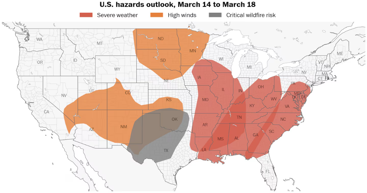
The biggest impact from the storm will probably be felt in the central and southern states from Friday through Saturday.
As the system, fueled by a deep dip in the jet stream, moves from the Rocky Mountains into the Plains on Friday, it will meet an extremely warm air mass streaming northward from the tropical Pacific Ocean and Gulf of Mexico.
In a sign of its intensity, this clash will cause the storm to dramatically strengthen, potentially breaking low air pressure records for the month of March in Oklahoma, Kansas, Minnesota and Wisconsin.
Here’s what to know about the storm’s impacts as it tracks through the region:
- Severe thunderstorms: Strong to severe thunderstorms that will fuel damaging winds, hail and tornadoes will probably develop in Iowa and Missouri on Friday afternoon, tracking into Illinois, Indiana, Ohio, Kentucky, Tennessee, Arkansas, eastern Texas, Louisiana, Mississippi, Alabama and Georgia from Friday evening through Saturday morning. The Storm Prediction Center has issued an enhanced risk (Level 3 out of 5) for severe thunderstorms on Friday in nine states from Iowa to Alabama. The highest risk for violent tornadoes appears to be across eastern Louisiana, Mississippi and Alabama on Saturday.
- Damaging winds: On the storm’s southwestern flank, damaging wind gusts in the 50 to 70 mph range will blow across northern Texas, Oklahoma, Kansas, Missouri and Arkansas on Friday afternoon and evening, probably causing widespread power outages.
- Critical wildfire risk: The combination of very strong winds and low humidity will contribute to a critical fire weather risk across eastern New Mexico, Texas, Oklahoma and southern Kansas on Friday.
- Heavy rain: From Saturday into early Sunday, heavy rain will fall across the Tennessee and Ohio valleys, potentially causing more flooding in a region that experienced deadly flooding in February.
- Snow: On the storm’s cold backside, a band of windswept snow will develop in the eastern Dakotas, Minnesota and Iowa on Saturday, with several inches of accumulation possible.
- Record high temperatures: On Friday, temperatures in South Texas will soar above 100 degrees, potentially approaching the United States’ national temperature record of 108 degrees for March.
The East will have several more days of dry and mild weather before what’s left of the storm moves through on Sunday.
The weekend will be particularly warm as a southerly wind flow steers in an air mass from the tropics. Temperatures may reach the 70s as far north as New York state.
From late Sunday into Monday, gusty showers and thunderstorms will arrive, bringing a wet and windy end to the weekend.
But, on the whole, the weather won’t be nearly as bad or dangerous in this region as it will be farther west.