Multiple rounds of severe thunderstorms are expected to tear across the Midwest on Monday. The storms, capable of producing damaging winds, large hail and intense tornadoes, are predicted to be most severe in the afternoon and evening.
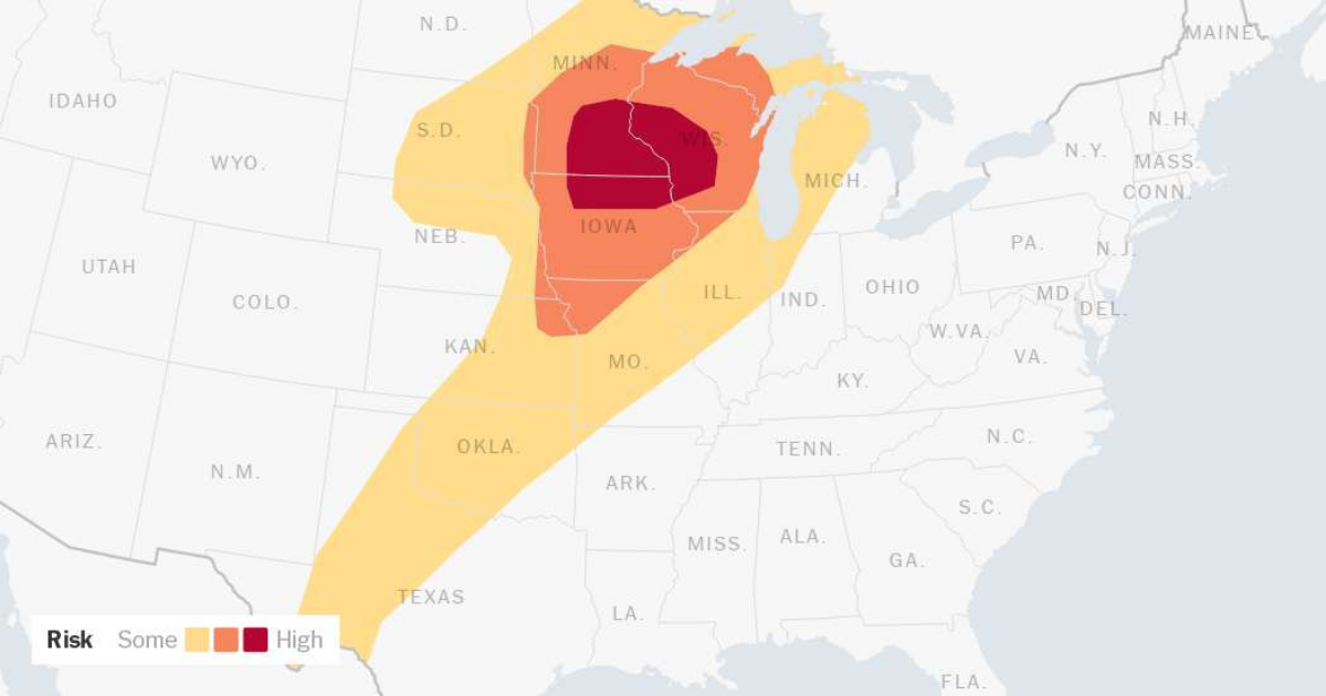
There’s a potential for thunderstorms in a large area all the way from West Texas to the Great Lakes, but central Iowa into southeast Minnesota and western Wisconsin is expected to be in the bull’s-eye of severe weather. This area, which includes Minneapolis and St. Paul, Minn., is under a moderate risk, what’s considered a Level 4 out of 5 by the National Weather Service’s Storm Prediction Center.
At this level, said Ashley Bury, a meteorologist with the Weather Service’s Des Moines office, winds over 60 miles per hour and hail larger than quarters are possible.
“In terms of tornadoes, the risk is a little bit on the lower end, but not out of the question,” Ms. Bury said. “We could see some larger ones, it’s just a matter of how things play out and what setup occurs.”
While thunderstorms aren’t unusual in this region in the spring, Ms. Bury said it was rare for the area to fall under a moderate threat level. “It’s not very often that we see this,” she said.
An area spread between the Northern Plains and the Upper Midwest is at a marginal risk, Level 1 out of 4, for heavy rains that could lead to flooding. The Quad Cities and the Twin Cities along with Milwaukee and Madison, Wis., could see instances of isolated flash flooding.
Strong storms are not unusual in the middle of the country in the spring, and in fact smatterings of thunderstorms unleashed strong winds, large hail and tornadoes in the Central United States last week. There were reports of hail as large as grapefruit in Texas and over a dozen tornadoes in the Great Plains on Friday, and thunderstorms combined with moisture flowing in from the Gulf brought flooding to New Orleans last Monday.
While last week’s thunderstorm activity was driven by numerous smaller storms moving across the country, the weather on Monday will be associated with one stronger system.
“We will start off with a couple systems, but by the time we go through the day Monday, it’s evolving more into a larger single system,” said Rich Bann, a meteorologist with the Weather Service’s Weather Prediction Center. “The evolution of the upper winds will allow that one system to become better organized.”
On Tuesday, the severe weather is expected to shift into Oklahoma and portions of the Ohio Valley and Northeast. There will still be a risk of large hail and damaging winds, with the tornado threat going down, “but it certainly doesn’t go away in places like Oklahoma,” Mr. Bann said.