Several of the weather features of a severe weather outbreak are going to be over Michigan late this afternoon and evening. There are also two weather features that could keep us out of widespread severe thunderstorms.
We call this severe weather potential a conditional severe weather set-up. The dynamics, better known as winds aloft, and wind shear are quite high. These two weather features give us the potential for significant severe t-storms.
But severe storms feed on warm and humid air here near the ground. Numerous and possibly widespread clouds, showers and thunderstorms are likely from 11 a.m. through the afternoon. This rain probably won’t allow the air to heat up and destabilize enough to feed severe thunderstorms. If we can stay cloudy and rainy enough into the afternoon, Michigan could luck out and escape severe storms.
So tornadoes, damaging wind gusts and large hail are conditional on a break in the clouds and rain stopping for a few hours in the second half of the afternoon.
Here are the severe weather forecasts from NOAA’s Storm Prediction Center (SPC). Notice they are aggressive with bringing severe thunderstorms north into Michigan. Also notice they are even more aggressive with a tornado and damaging wind event just to our south in Illinois, Indiana, Ohio and Kentucky.
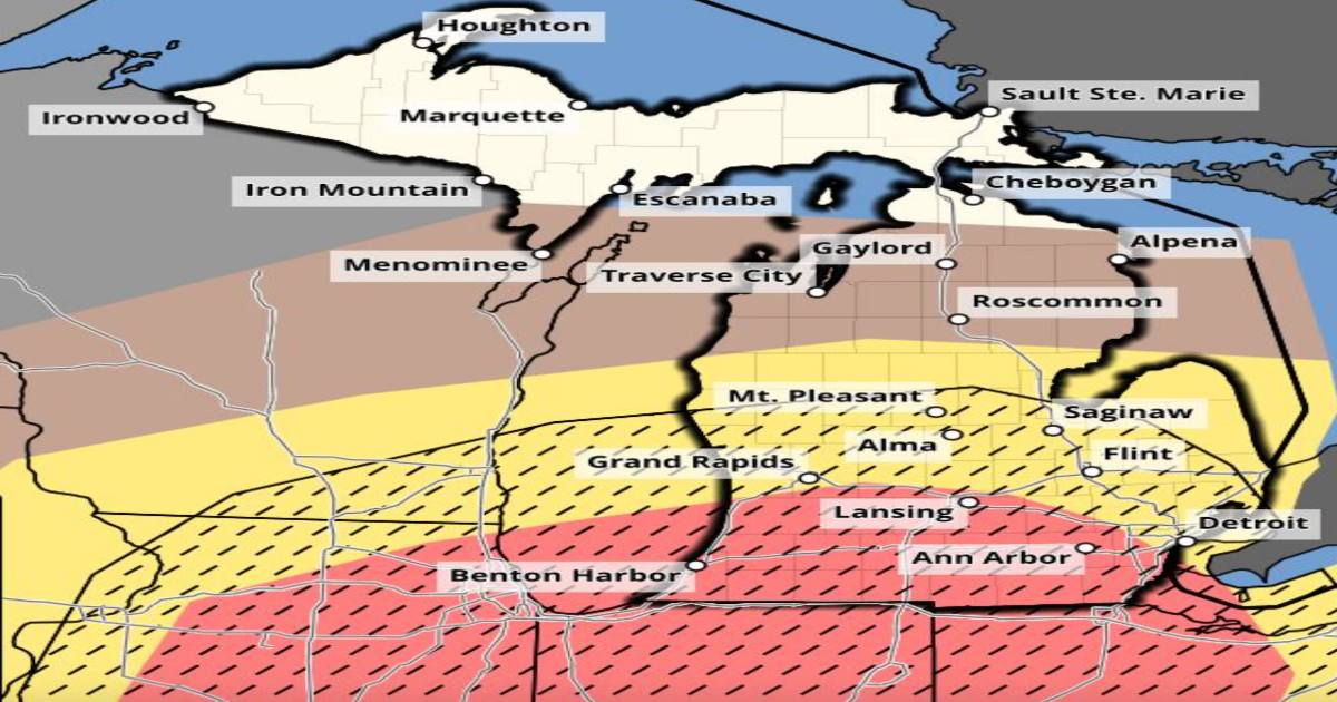
Let’s start with the most likely severe weather condition- quick but damaging wind gusts. A little over half of Lower Michigan is in the higher chance of severe wind gusts. An area from Lansing southeast to Ann Arbor and southwest to Kalamazoo is in the higher 30 percent chance of scattered severe wind gusts. Also note that SPC has the black hatched area from Saginaw and Mount Pleasant southward for the potential of high-end 75 mph gusts.

Severe wind gust forecast for this afternoon and evening. Note the black hatched area denoting wind gusts over 75 mph possible.NOAA
At this time of year the colder air aloft actually allows hail to be easily produced. Park your vehicles in the garage this afternoon and evening. Large hail is most possible in the same southern half of Lower Michigan.

Large hail forecast for this afternoon and evening.NOAA
Finally, we all worry about tornadoes. The tornado threat is here today, and very real if the storms overcome wet, cool, stable air. This is just going to be a wait-and-see situation.

Tornado forecast for this afternoon and evening. Note the black hatched area of strong tornadoes is south of Michigan.NOAA
Here’s the radar forecast from this morning to midnight. The winter weather mess will end by noon for most of us, and then we transition to thunderstorms. Notice the last line of thunderstorms this evening runs through Coldwater, Ann Arbor and Detroit. I feel that line of storms has the highest threat of being widespread severe.

Radar forecast from 8 a.m. today to midnight tonight.NOAA
This is a tough one, and why it’s pegged as a “conditional” severe weather situation here in Michigan. My feeling from my 36 years of professional forecasting in the Great Lakes is it will be cloudy and rainy enough midday to prevent a high-end severe weather outbreak. On the other hand, with the dynamics aloft we have had rare “cold” tornadoes and severe weather in the past. Ohio has had a few notable tornadoes with temperatures only in the 50s but strong upper-air dynamics.
I’m going to continue to update you at MLive.com/weather.
