ATLANTA – 1:25 P.M. SUNDAY: A ground stop has been issued at Hartsfield-Jackson Atlanta International Airport due to thunderstorms. This is expected to impact departures until 2:30 p.m. (Updated from 2 p.m.)
12:05 P.M. SUNDAY: The Atlanta Braves have postponed today’s game against the Miami Marlins to Saturday, Aug. 9, at 1:15 p.m. as part of a split doubleheader. Fan tickets from Sunday’s game will only be valid for this replacement game.
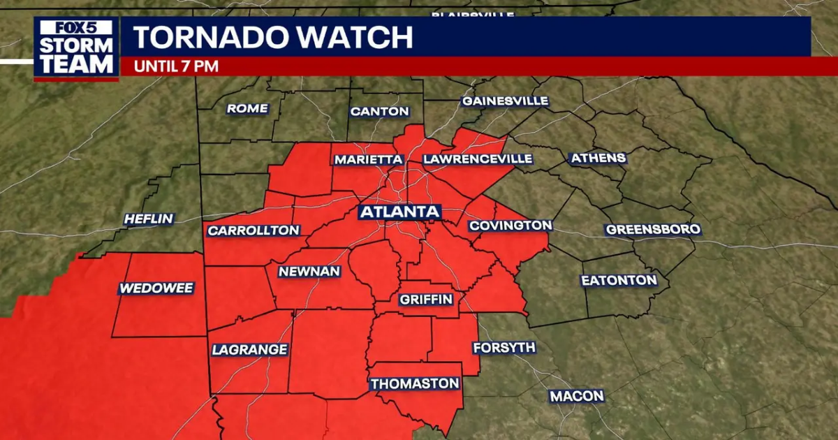
11:15 A.M. SUNDAY: A new Tornado Watch has just been issued for metro Atlanta and points eastward until 7 p.m. tonight (just updated from 5 p.m.). The alert applies to Paulding, Newton, Cobb, Spalding, Dekalb, Gwinnett, Fulton, Clayton, Butts, Meriwether, Lamar, Coweta, Carroll, Rockdale, Upson, Heard, Fayette and Douglas counties.
What is difference between watch and warning?
A watch means that conditions are favorable for a hazardous event to occur, while a warning means the event is occurring or imminent and requires immediate action.
9 A.M. SUNDAY: FOX 5 Atlanta is closely monitoring a storm system expected to bring severe weather to metro Atlanta and North Georgia later today, including the potential for damaging winds, heavy rainfall and an isolated tornado.
Watch FOX LOCAL starting at 9 a.m. for more weather info throughout the morning.
As of early Sunday morning, radar showed heavy showers — though not thunderstorms — moving through Bartow, Dawson and Lumpkin counties. These showers, which are not producing lightning, are expected to track through Dawsonville and into the Ball Ground and Hall County areas in the coming hours.
The main weather threat remains further west at this time, where a line of strong storms currently stretches across parts of Alabama and Mississippi. A Tornado Watch has already been extended into northwest Georgia, and the risk of severe weather in the metro area is expected to increase by early afternoon.
All of North Georgia is under a Flood Watch that will remain in effect through Sunday evening. Forecasters predict widespread rainfall totals of 2 to 4 inches, with localized amounts possibly reaching 5 inches. The rain is expected to arrive in several waves throughout the day and into tomorrow, rather than as a steady downpour.
Temperatures will vary across the region as a cold front moves in. Highs in the northwest corner of the state are expected to remain in the upper 60s and low 70s, while Atlanta will top out around 75 degrees. South of the metro area, highs could approach 80.
Download the FOX 5 Storm Team app
The storm threat may impact events in the area, including the Atlanta Braves game against the Miami Marlins at 1:10 p.m. at Truist Park. Fans are advised to monitor conditions and stay weather-aware.
Following the storm system, cooler temperatures are forecast for the early part of next week. Highs will dip into the low 60s, with overnight lows falling into the 40s and even 30s in some areas. A return to milder weather is expected by Thursday, with temperatures rebounding to the mid-70s.
ORIGINAL STORY
As Atlanta experiences unseasonably warm temperatures heading into the weekend, forecasters are tracking a weather shift that could disrupt outdoor plans and bring a burst of cooler air next week.
What we know:
A ridge of high pressure across the Southeast has kept storm systems at bay in recent days, allowing for above-average warmth. That pattern has helped Atlanta set at least one temperature record this week, with another record possible before the weekend ends. Highs on Saturday are expected to climb near 90 degrees.
That pattern will break down this weekend, opening the door for a stalled cold front to finally move east. Rain and storms will arrive in Georgia on Sunday, with isolated strong to severe storms possible, mainly in the afternoon and evening hours.
The system currently producing storms across the Midwest will gradually shift east. While it will weaken somewhat before reaching Georgia, it could still produce heavy rain, gusty winds, and frequent lightning.
Rain expected to arrive Sunday
Timeline:
Through Friday, the cold front remains stalled to the west, keeping the severe threat away from Georgia. On Saturday, the risk zone shifts slightly closer but remains confined mainly to western Alabama and areas farther west. Metro Atlanta is not under any severe weather threat on Saturday, though warm temperatures will continue.
By early Sunday morning, a few showers may begin to reach far northwest Georgia around sunrise. The main line of storms is expected to arrive closer to midday. As temperatures warm through the afternoon, the threat for severe weather increases, and storms will spread eastward into the evening.
Rain is expected to wrap up early Monday morning. After that, a cooler air mass will settle over the region, bringing a noticeable drop in temperatures. Lows in the 40s and highs in the 60s are forecast from Monday through midweek. Some areas could see temperatures dip into the 30s by Wednesday morning, raising the potential for frost or even a light freeze.
Severe weather possible
What we don’t know:
Forecasters are continuing to analyze new data to assess the full extent of Sunday’s severe weather potential. Specifically, it’s too early to determine whether tornadoes will be a threat in Georgia. As more data becomes available, the forecast will be fine-tuned.
Download the FOX 5 Storm Team app
Be prepared
Why you should care:
Sunday may not be a total washout, but outdoor plans could be interrupted by storms, particularly in the afternoon and evening. The possibility of isolated strong to severe storms means anyone spending time outdoors should monitor weather alerts closely.
The cooler air behind the front could also catch people off guard next week. While the warmth of this week might feel like spring has arrived for good, the return of 30s and 40s next week could threaten early plantings and bring the risk of frost or freezing in parts of North Georgia.
AtlantaWeatherNewsInstastories